

Upper Big Tujunga
Last weekend we decided to thru-hike Upper Big Tujunga, a 3-mile adventure from Big Tujunga Road Bridge to the Colby day-use area. Although we couldn’t find any current trip reports of anyone having recently hiked Upper Big Tujunga besides Christopher E. Brennen’s 16-year old report: Upper Big Tujunga, we still decided to attempt this adventure.
The start to Upper Big Tujunga is the same as Big Tujunga Narrows (Monkey Canyon), which is a dirt parking lot with a lone tree. After having left a car by the bridge at Colby day-use area, we drove back to the start. Crossing the Angeles Forest Highway, we then descended down to Big Tujunga canyon carefully. It wasn’t sooner than 5 minutes that we encountered a rattler frolicking in the middle of the trail. We had to patiently wait for it to slither out of the way, but it only moved to the side, so we nervously bypassed it as quickly as we could. We used the ropes in place to finish the descent down to the canyon.
Down Upper Big Tujunga Canyon
Once at the creek we veered right and headed upstream. We checked out some wrecked cars and ruins of a concrete gauging station. After that, Mill Creek intersects with Big Tujunga so we stayed on the right to head towards the Narrows bridge.
 gauging station
 cars thrown off from the highway….
 The Narrows Bridge over Big Tujunga Road
Although at this point we were making good time, we didn’t imagine that we would have to stay on the creek the entire time. As soon as we passed the Narrows Bridge, we started to fall behind the estimated times on the trip report. The only sure way up was to stay boulder-hopping and bush-wacking on the creek as the banks had overgrown brush, fallen trees, and poison oak.
There was no sign of a “use-trail” or any sign of anyone been down there at all, and I can only imagine what the Station Fire must’ve changed. Although it wasn’t going as expected we all stayed in good energy. It was a hot day and being off-trail and wading in the canyon waters was pretty fun.
 Leaving the bridge behind
 This was our view 90% of the time
 Wading in the cool creek
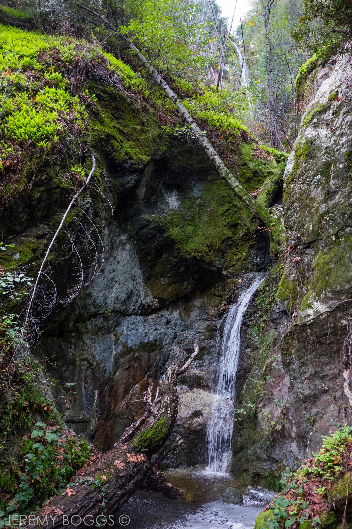
First Falls
It took more than three hours to reach the start of the narrows section and the first obstacle came in sight, a beautiful 20ft waterfall. The only way to ascend the falls is immediately to the left. This “straightforward climb” was moderately challenging. You basically wedge yourself up between a slot (slightly chimneying yourself up).
 In awe of the narrows segment…
 Looking back at the first falls….
After the first climb, there was some scrambling on the slab and soon that segment of narrows finished and it was back to the boulder-hopping on the creek.
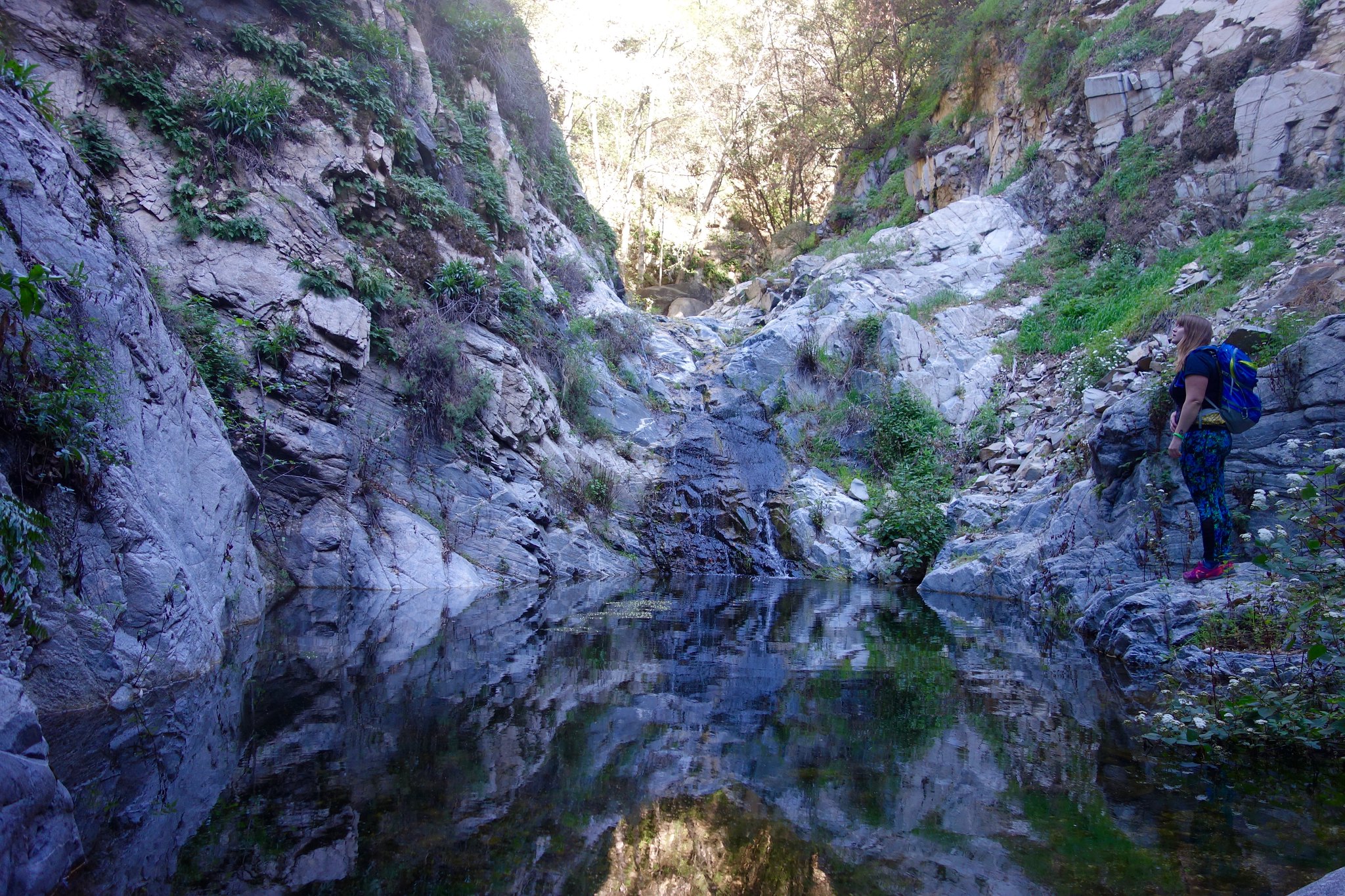
Main Falls
After some time back on the creek we encountered the largest falls of the Upper Big Tujunga: an impressive 30ft fall cascading down a large pool, resembling a small lake. The area around the pool was a sandy beach, perfect place for lunch as we knew the most challenging obstacle lied ahead of us.

The way we were supposed to ascend these falls was to climb up a gully and follow an “airy-use-trail” across a sharp ridge 150ft above the river.
The group followed Jeremy’s lead up a steep loose bank that did indeed look worse from below. We were incredulous at the sight of this climb from below. I was going in good speed but the terrain was quickly getting looser and steeper as the rest of the group beneath me was negotiating the climb. I slipped down a ways with the scree, not really feeling certain that I was going to stop falling. After I slipped a couple of times I definitely lost my confidence in my footwork and balance. We stayed planted on the steep bank (I’m still not too certain if we stayed left enough to the gully). Jeremy left to go check out the sharp ridge that we still needed to cross to see if it was going to be worth clearing this climb. He came back to tell us that it doesn’t look safely feasible as the terrain is more steep n’ loose, but this time with a cliff back-drop.
At this exact place, we were only at the half-way point, 4 hours in. It would take just as long if we could have cleared this climb to reach the car at Colby camp, as it would be to turn around and exit the canyon the same way. However, this time we would try to take a short cut up from under the Narrows Bridge to get back to the highway. It wasn’t even a tough decision…
Hiking Back
We were relieved once we were all safely back down to the sandy beach from that miserable climb. We hiked backed down retracing our route and within a fast couple of hours and little sunlight, the bridge was back in sight.
 We joyfully returned the same way, sunlight bathing the canyon.
We spotted a route that seemed doable. There was no trail, just exposed class-4 sections that were painfully slow-going after an 8-hour adventure. Walking across the bridge on the highway felt unreal. Not a single person came back without some cuts and bruises to show for what we just went through.
Recap Thoughts
I’d still recommend going to the first falls, just as John Robinson has it noted in his Trails of the Angeles book. I wouldn’t try further than that, unless you knew you would turn around after seeing the main falls. I’ve seen footage of people doing this canyon downstream, some with canyoneering gear, and others cliff-jumping the falls. I have been wanting to see this canyon for some time and finally got to experience it, along with its secret falls. The rugged San Gabriels never disappoint.
Check out the full album on Flickr: ![]()