

East Fork Hike

Thru-hiking the East Fork is a beloved adventure of the San Gabriels as the experience allows for an appreciation of its rich mountain history and spectacular scenery. The picturesque East Fork country transitions from a woodsy forest of pines to a rugged precipitous gorge of the Narrows. It’s dotted with mines, cabin ruins, and old roads which evoke images of the days gone by. This post serves a guide as well as a trail report from our trip in May.
DIFFICULTY: Strenuous (1 day), Moderate (2 days)
Distance: 16.5 Miles
Elevation Loss: 4560 feet
USGS Topo Maps: Mount San Antonio, Mt. Baldy, Glendora
Best Season: Year round, except after heavy rainfall
More information:
My CalTopo Map
Christopher Brennan’s Trip Report
Modern Hiker for Bridge to Nowhere Trail
Hike Log:
Start: Vincent Gap 34.3732, -117.7531
Vincent’s Cabin 34.3679, -117.7444
Mine Gulch Junction 34.3439, -117.7275
Fish Fork 34.3059, -117.7335
Falls Gulch 34.3034, -117.7335
Iron Fork 34.2958, -117.7415
Bridge to Nowhere 34.2832, -117.7471
Allison Gulch/Swan Rock 34.2611, -117.7492
End: Bridge to Nowhere Trailhead 34.2370, -117.7653
East Fork Adventure
Traversing the East Fork has long been on my list of classic San Gabriel hikes, a place to be emerged in the heart of its wilderness. Summer was drawing near, a perfect time for a lively group outing. There were a total of 12 of us ready to revel in the spectacular East Fork Country.
A very long shuttle is the crux of this adventure. The shuttle length is 75 miles, which can make a same day set-up exhausting for the rest of the hike. It is best to get dropped off and have a car waiting for you at the terminus, which is the Bridge to Nowhere trailhead. Finally, once a car is left there, drive through Wrightwood, up the Hwy 2 to Vincent Gap
Since figuring out the shuttle was going be the most stressful part of the plan, our friend Darryl gifted us with a service shuttle that rode us from Azusa to Vincent Gap, taking a ton of weight off our shoulders.
Friday night at Vincent Gap: van doors were yanked open and immediately the cold mountain winds pierced our warm bodies. Time for the weekend warrior transformation. We hastily threw some layers on, strapped on our packs and did a group huddle, firing up the energy of the group.
A Fugitive’s Cabin, A Missing Hiker
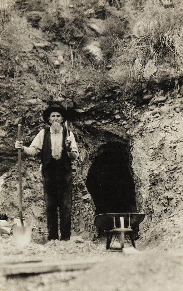
After 200 yards on the gated road, theres a junction with Mine Gulch Trail deviating on the left from Big Horn Mine road. Follow the trail down the canyon, as the road leads to Big Horn Mine is a 4 mile detour. The Big Horn Mine was discovered by Charles “Tom” Vincent in the 1890s, naming it after the bighorn sheep he hunted in the area. He was a mountain man, civil war veteran, prospector, hunter and fugitive who lived a recluse life based from his cabin high up in Vincent Gulch.
At. 0.7 miles, a flat spur with a subtle path intersection leads to Vincent’s Cabin, our campsite for the night. We were expecting a few others Saturday morning so this served as the meeting point.
Some time during camp setup, we realized we were short one person. Oops. The turn-out to Vincent’s Cabin is a not so conspicuous one. A few of us grabbed headlamps and frantically ran up and down the trail, blaring out his name, listening for any faint response in the silent forest. The canyons reverberated our calls a long way down, dashing our hopes for an answer. Therefore, we decided to resume searching by daylight tomorrow since our friend was fully equipped to stay safe overnight wherever he was…
 A moment of beauty in the midnight hour of despair
The next morning our friend casually roamed into our camp site. He was ok, he missed the turn-out where we left the trail and so he had hiked back up to camp at Big Horn Road.
We spent the rest of the morning loitering around the meadows. Spirits were high and the energy was infectious, more so when the last of our friends arrived. Quite a scene it was: we converged into one large assembly of hikers, a horde of rugged backpackers at Vincent’s Cabin. We were now ready to start our slow trudge to Fish Fork camp for our overnight stay
 Miner Vincent’s Cabin sat dilapidated for decades until the USFS beautifully restored it.
Air wrecks, Fish Fork
Once back on Mine Gulch Trail (fun fact: you’re actually descending Vincent Gulch), the descent is 2000 ft and 4.4 miles until reaching the canyon bottom. Views opened up of our forthcoming path in the spectacular East Fork Country.
 Views from Vincent Gulch of East Fork country
 First full day of backpacking. Descent of Vincent Gulch into the canyon proper
 Transition from a forest of pines to oaks to mark the lower elevations.
Eventually, the trail emerges into Mine Gulch Junction where Vincent Gulch, Mine Gulch and Prairie Fork all meet. Take a small detour to check out a historic aircraft wreck in Vincent Gulch
 Mine Gulch
On February 6, 1974, a glider with two men aboard flew out of Llano, CA and headed towards the San Gabriel Mountains. After soaring in the high mountain winds, they flew into a violent downdraft. The pilot crash-landed on the canyon bottom and the glider was completely destroyed.
 Slight detour to see the historic plane wreckage from the 70s.
But both the pilot and his passenger walked away with only a few scratches. The glider was a Schweitzer 2-32, now a wreck scattered in rusting pieces. You can find more neat information on this and more aircraft sites in Historic Aircraft Wrecks of Los Angeles County by G. Pat Macha.
 Unique geological formations lining the walls
Past the aircraft wreck, the adventure onwards involves mostly boulder hopping, some bush-whacking and creek fording. Every turn of the canyon gave way to small waterfalls, massive boulders, and high rising canyon walls. Although the scenery was pleasant, a trail less route equals a very slow pace. Navigating around obstacles expends energy and time. Everyone succumbed to at least one tumble during the entire hike. Body parts sported colorful bruises and plentiful scrapes. One unlucky hiker even went home with a bum full of thorny needles! Ouch! (I could only imagine)
 Making our way up and around obstacles. Photo by Jeremy Boggs.
At roughly 9.5 miles the junction with Fish Fork is reached. Theres a spacious primitive campsite across from the river where we set up camp for the night.
 Fish Fork camp
Fish Fork lies in a jagged canyon tightly wedged between Pine Mtn Ridge and San Antonio ridge. Melting snows from high up Mt. Baldy nourish the stream that plunges down its narrow walls and makes it way to the East Fork.
Chock full of alder and bay, narrow with soaring walls, its clear stream tumbling over boulders, Fish Fork is one of the wildest and most beautiful settings in the San Gabriels.
-Jerry Schad, Afoot & AField Los Angeles County
Schad also noted of a waterfall 1.5 mi up Fish Fork which “drops about 12 feet into an emerald green pool set amid sheer rock walls”. We left this detour for another time.
Narrows & an Eternal Bridge
On Sunday, the last day, we packed up and headed out from Fish Fork. Only .2 mi downstream, a narrow cascade appears on the left, Falls Gulch. A refreshing vista amid the hot canyon.
 Brandon next to Falls Gulch Falls
 Slab with sinuous streaks
Iron Fork is the next prominent junction. Be sure to take a break and explore a bit up this fork. On a small plateau once stood a cabin of George Trodgen, an old timer popular for his hospitality. His place became a central point for mail, mining business, or company. The cabin is long gone now, washed away by recurrent floods. Primitive campsites can be found along this fork.
Then, just after Iron Fork lies Hobo Dave’s hut, possibly the former cabin of Oliver Justice, another old timer. His hut also lies in proximity Justice’s grave.
The section between Iron Fork and the Bridge to Nowhere is called the Narrows, the deepest gorge in southern California. The rise from the floor of the Narrows to the peak of Iron Mtn is 5,200 in 1.75 miles!
 Trekking in the sheer vertical narrows. Photo by Jeremy Boggs
 Sheer rock backdrop
 Deep in the canyon amongst slabs of rock in the narrows. Photo by Jeremy Boggs
After numerous creek crossings and a few more miles, a sharp turn to the right leads the impressive concrete structure known as the Bridge to Nowhere.
 Our group taking a moment to recoup from the long trek. We were now joining the day hikers at the Bridge to Nowhere.
 Heading up the Bridge. A very steep and exposed incline. Photo by Jeremy Boggs
In the 1920s, Los Angeles County began constructing a scenic highway all the way up the East Fork canyon to Wrightwood. Once the road reached the narrows, a concrete bridge was necessary to stay high above the waters of the gorge. However, an unprecedented storm sent record levels of flooding waters down the East Fork, obliterating most of the highway. Only the bridge survived. The damages were so extensive, the county abandoned their plans for a highway and left a new concrete road bridge standing alone in the middle of wilderness.
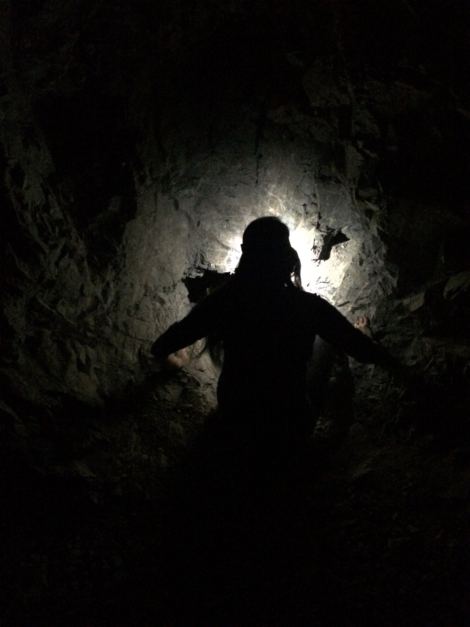
 The caved in scars on the cliffside has long covered the tunnel.
Hidden Mines, Secret Falls
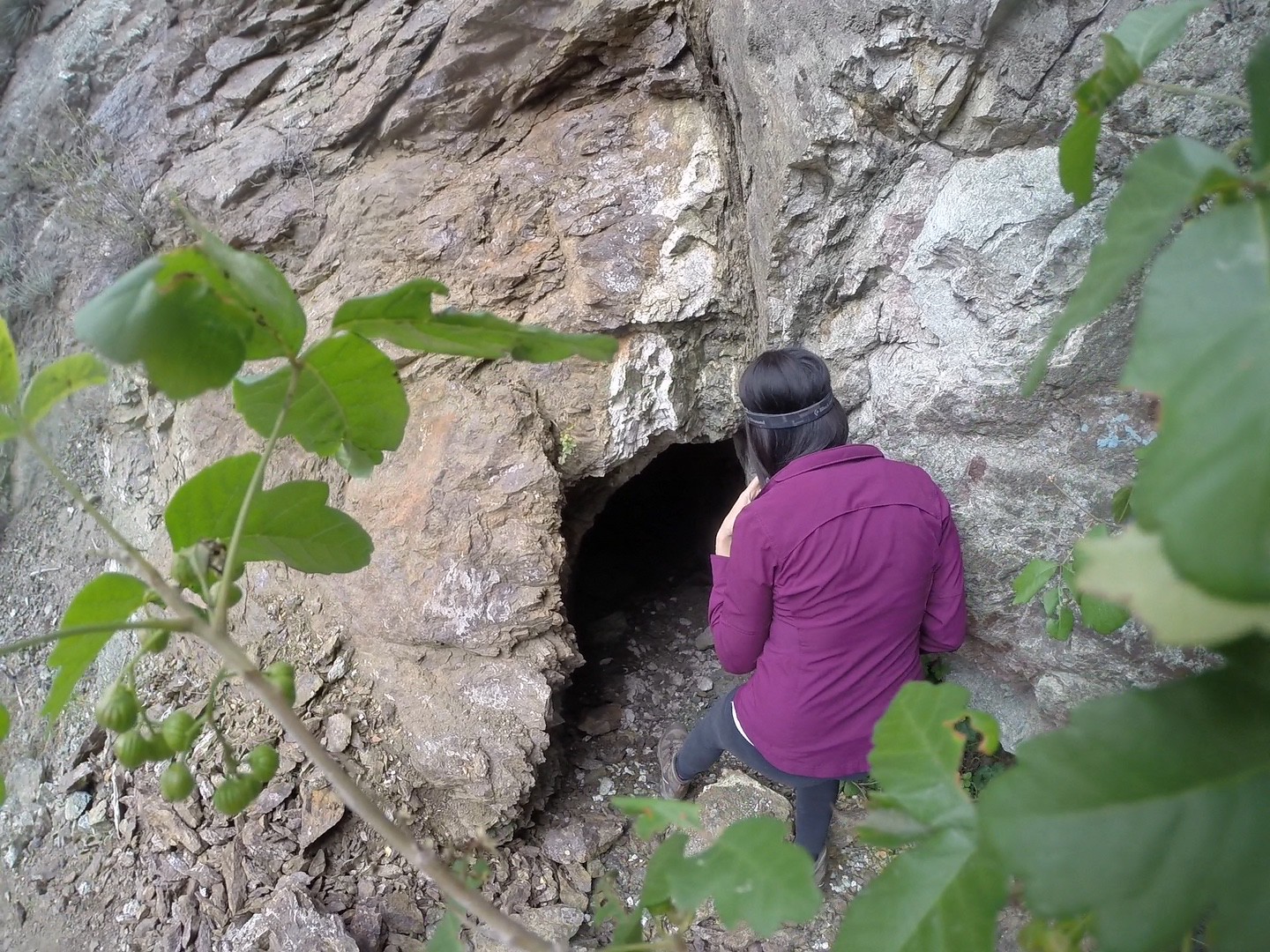
So, once up at the bridge, we opted for exploring the Horseshoe Mine, located south of the Bridge, downstream.The mine was originally patented in the early 1900s by the Saunders family and is part of their private land. Apparently the Saunders continue to license bungee operations at the Bridge today! I suggest reading Hugh Blanchard’s account as hes put extensive research into uncovering the history of the mine and charting its various tunnels.
 Darryl and Valerie heading down towards the mine.
 Looking out from Horseshoe Mine
Further on downstream, we stumbled upon a long black hose floating in the waters belonging to some prospectors encamped in the banks. They pointed out a hidden waterfall nearby that apparently was well worth the detour. We thanked them and ran up the gulch…
 A modern prospectors pipe bringing in water from upstream.
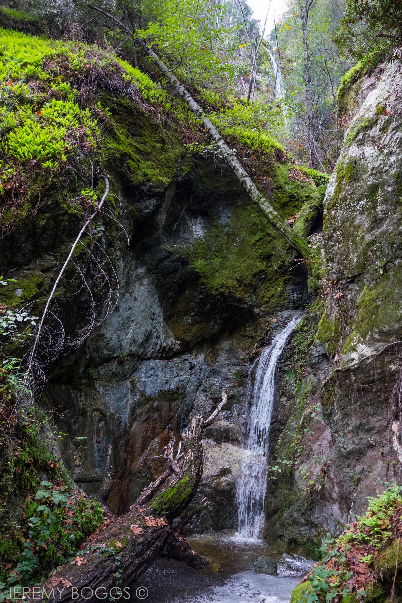
We received more than we bargained for. These spectacular falls took our breath away! Devil Gulch Falls drops 50′-60′ feet off a vertical moss-covered rock wall into a lush grotto. Check out my guide to get to Devil’s Gulch.
 Ruins dotted the gulch
 Devils Gulch Falls
We finished our long detour by reconnecting with the East Fork trail, one last haul to get out of the canyon and back to the car. The onset of fatigue beginning to take effect on our bodies and minds. The various lights coming down the canyon helped distract from the long march.
 Darryl and Vallerie in the wash, passed Rattlesnake Canyon. The lights were constantly changing
Soon, you pass a junction where Allison Gulch flows into the East Fork. A loop to Allison Mine routes here as well as some exploratory waterfall finds. About 300 yards further on, search for the white swan etched into a wall.
 Swan Rock up above
The last river crossings head up to Heaton Flats, named after miner Billy Heaton who homesteaded these flats. He used to work on his mine nearby everyday “rain or shine”. You can still visit his mine and goes unnoticed by most day hikers. Details on my guide
Finally, just a few hundred yards more of the road leads to the locked gate for the Bridge to Nowhere trailhead parking lot, the terminus for this hearty long adventure
Check out the full album on Flickr: ![]()