

Mount Gleason Nike Site (LA-04)
Perched high above Los Angeles at over 6,500 feet, the Mount Gleason Nike Site (LA-04) was a mountaintop fortress built for the atomic age. As the first Nike installation planned and constructed in the Angeles National Forest, it was also the longest-serving, active from 1955 to 1974. For nearly two decades, this remote outpost witnessed the full evolution of Nike missile technology, from the sleek, supersonic Ajax to the formidable, nuclear-armed Hercules. Mount Gleason also held the unique distinction of being the highest Nike Site in the world!
 Nike-Ajax in background & Nike Hercules at Mt. Gleason Nike Base, 1959. Credit: LAPL
Origins
The Nike program was born out of the aftermath of World War II, at a time when global warfare was entering a new era.
Recognizing the urgent need for a more advanced air defense system, the U.S. Army called on Bell Labs in 1945 to develop something entirely new: a guided missile system designed to intercept enemy aircraft. They named it Nike, after the Greek goddess of victory.
As the Cold War gripped the world, the fear of a Soviet attack on American cities grew more real by the day. The devastation of Hiroshima and Nagasaki was still fresh in the national memory.
Then, in 1949, the unthinkable happened: the Soviet Union tested its first atomic bomb. A countermeasure had to be found immediately…
The solution: the Nike Ajax, the nation’s first anti-aircraft missile system – built to ensure America’s survival.
 The Cold War: An uneasy peace that lasted for nearly half a century
To shield America’s most vital cities, rings of Nike missile sites sprang up around major urban centers—Los Angeles alone was encircled by 16, forming one of the most heavily fortified defense perimeters in the nation. Buried underground, the missiles sat on constant alert, ready to rise and launch at the first sign of danger.
 A ring of Nike missile sites surrounding the greater Los Angeles area
Mount Gleason was one of several Nike missile installations situated in the rugged terrain of the Angeles. The other sites were Barley Flats/Mount Disappointment (LA-09), Los Pinetos (LA-94), and Magic Mountain/Lang (LA-98). Each played a vital role in the Cold War defense of Los Angeles.
 Wide view of LA-04, showing launch area (left) and barracks (right), 1988. Credit: Historic American Engineering Record (HAER No. CA-57) and Library of Congress (LOC)
Construction on Mount Gleason began in 1954, carried out by the U.S. Army Corps of Engineers with permission from the U.S. Forest Service. Like other standard Nike installations, the base was divided into three main sections:
- Integrated Fire Control (IFC) Area – This section housed the radar and computer systems used to detect and track enemy aircraft and to guide Nike missiles to their targets.
- Launch Area – Equipped with underground storage magazines, this is where missiles were kept until they were raised and fired.
- Administration Area – This area served as the base’s headquarters and included barracks, offices, and support facilities for personnel.
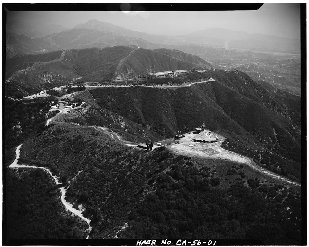
At Mount Gleason, the Administration and Launch facilities were built side by side on a prominent knoll, while the IFC area was located about a mile and a half to the west, on the summit of Mount Gleason itself.
 Satellite Image of LA-04 – Mt. Gleason Nike Missile Site
 Aerial View of Mt Gleason showing Nike structures still active, including its three silos, 1971
The structures listed below aren’t a complete record of all the facilities that once stood at Mt. Gleason Nike base — but they include the significant structures documented in declassified military files and civilian records.
Administrative Area
The Administrative area of a typical Nike missile site was designed to meet the basic needs of the crew stationed there. As a result, Nike sites often featured austere, utilitarian buildings constructed mainly from concrete blocks and wood framing. But Mount Gleason stood out with a unique architectural feature: many of its structures were topped with steep, Swiss-style roofs to help heavy snow slide off more easily during the winter months.
 Admin buildings with Swiss-style roofs to aid snow removal, circa 1978. Credit: Paul Rippens
The Administration site included several key buildings: a sentry box, two barracks, a multipurpose building, and the mess hall.
- Sentry Box (Guardhouse): Small, square cinder-block structures located at the entrance of the site, serving as the first line of access control.
- Multipurpose Building: The hub of the base, this facility housed administrative support services and coordinated day-to-day operations, serving as a kind of headquarters.
- Bachelor Officers’ Quarters and Enlisted Men’s Barracks: At Mount Gleason, officers and enlisted men initially shared the same barracks, leading to cramped living conditions and serious morale problems. A separate facility was eventually built to provide dedicated housing for the enlisted personnel.
 Admin site as it looked in the late 1980s. Credit: LOC
Launch Area
The Launch area was where Nike missiles were maintained, stored, tested, and fired at a moment’s notice. Perched on a prominent knoll at Mount Gleason, the site rose steadily from south to north, commanding the surrounding terrain.
 Mt. Gleason LA-04 Launch/Admin Area
 Mt. Gleason Nike Site with Admin and Launch site sloping upwards with 3 missile silos circa 1978, LA Co Fire Dept
The Mount Gleason Launch Area included five key buildings: a ready room, a fallout shelter, a missile assembly area, a warheading building, and a generator building. These were situated alongside three underground missile storage bunkers, where the Nike missiles were stored until launch.
Sketch Map of Administrative and Launch Areas of Nike Site LA-04. Credit: HAER (Library of Congress)
Site sketch of the underground silos at LA-04, with code names Alfa, Bravo, and Catfish. Credit: HAER (LOC)
 Aerial of Mt Gleason 1980, clearly showing the details of the Launch Area
- Ready Room: This was where soldiers remained on high alert in 24-hour shifts, prepared to respond instantly to any emergency launch order. Because raising the missiles from their underground magazines and preparing them for launch had to be completed in under five minutes, it was critical to have personnel stationed here at all times, ready to act at a moment’s notice.
- Fallout Shelter: Built in 1961, this reinforced shelter measured 48 by 27 feet and could house up to 60 people in the event of a nuclear strike.
- Missile Assembly Area: This area was where missiles were uncrated, assembled, and tested before deployment. The building featured large, garage-style doors at both ends, allowing missiles to be easily rolled in and out.
- Warheading Building: This was the secure facility where missiles were armed with their nuclear or high-explosive warheads. The area was surrounded by an earthen berm designed to contain any accidental explosions that might occur during the service.
- Generator Building: Although Nike sites were connected to commercial power grids, they also required reliable backup systems. Mount Gleason’s generator building housed three large diesel generators—vintage units manufactured by General Electric, believed to date back to World War II—that could sustain operations in the event of a power outage.
- Sentry Control Station: Centrally located within the Launcher area, this facility served as the command center for site security. It housed controls for perimeter locks, protective lighting, electric gates, and the ADT alarm system. The station guarded the exclusion area—the most restricted zone of the Launch site, protecting missile storage and firing operations.
- Three underground missile magazines (codenamed Alfa, Bravo, and Catfish) – formed the core of the launch area.
-
-
- Each underground silo had overhead double elevator doors and ground-level launch pads. For launch, the magazine doors opened, the missile was raised by an elevator to ground level, and then moved horizontally onto the surface launcher.
- Personnel accessed the magazines through reinforced entrances fitted with heavy blast doors.
- A small control room, located behind several blast-resistant doors, provided operational oversight from within
- During alerts, soldiers would disappear underground into small personnel rooms—bunker-like quarters barely larger than a prison cell—where they worked 24-hour shifts. Cut off from daylight in their 6-by-10-foot concrete tombs, crews lived on bunks and survived on only the most essential supplies.
-
 Silo Alfa, 1988. Credit: LOC
 Double Double door personnel entry access into the Bravo Silo, Credit: LOC
 Elevator Door At Catfish Silo, Credit: LOC
 Elevator Lift In ‘Catfish’ Silo. Credit: LOC
 Bunk area inside ‘Bravo’ silo, 1988. Credit: LOC
 Cutaway View of Underground Magazine. Taken from the Department of the Army Technical Manual (FM 44-80) “Procedures and Drills for the Nike I System”
 Missile assembly building at the Launch area. Credit: LOC
In the late 1950s, Mount Gleason was converted from a Nike Ajax to a Nike Hercules installation, making it one of the first sites upgraded to nuclear capability. This second-generation missile was far more powerful than its predecessor—nuclear-capable, with greater speed and extended range.
 Comparing Ajax and Hercules
Collection of Nike missiles throughout the US. Credit: Getty Images
With the arrival of nuclear weapons came the need for tighter security. Hercules sites typically deployed trained sentry dogs, along with the construction of kennels and enhanced perimeter fencing. While on duty, the dogs patrolled the area between two steel security fences surrounding the missile launch zone, creating a dog runway.
Sentry dogs, often German Shepherds – were critical in base security, especially during night shifts. Each dog was assigned to a dedicated military police (MP) handler who was responsible for its care and patrol duties. These dogs were deliberately trained to be highly aggressive toward intruders and generally friendly only toward their handler.
 Scenes of killer Nike Sentry Dogs
 Double Fence Around Launch Site, 1988. Credit: LOC
 Dog kennels were added near the Mt. Gleason Launch area in 1959-60 for the sentry dogs. Credit: LOC
Military Folk Art: Missile Silo Murals
Across the country, Nike missile site bunkers often featured murals painted directly on the walls by enlisted missile crews who spent long hours on 24/7 alert. At Mt. Gleason, each of the three underground silos had its own unique artwork, created by the servicemen stationed there. These murals captured both the monotony and the camaraderie of life below ground.
Artwork at Mt. Gleason included humorous characters, heraldic felines, and stylized Nike shields—reflecting unit pride and mission identity
IFC Area
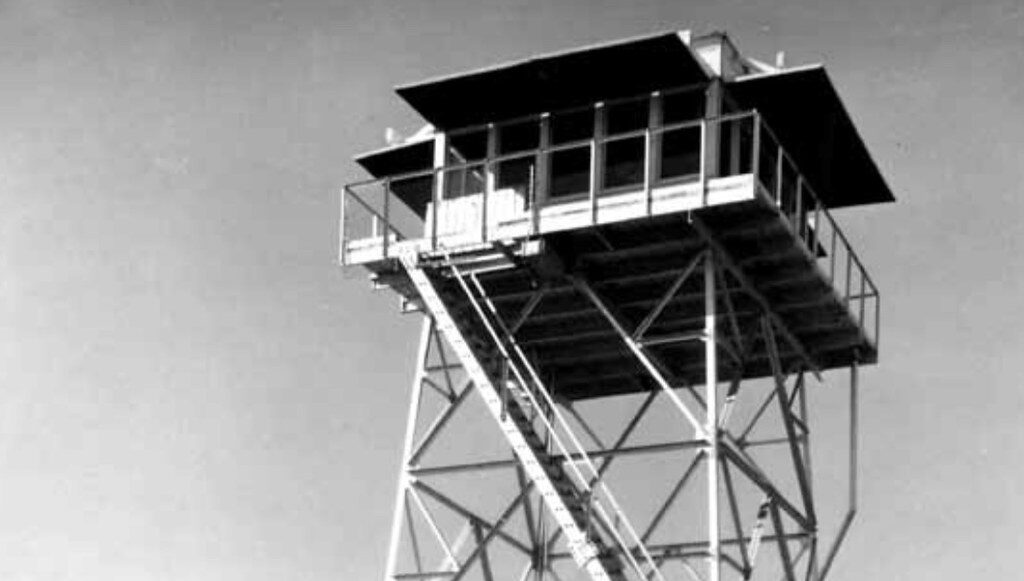
The Integrated Fire Control (IFC) Area—also known as the Battery Control Area—was the command and control center of a Nike missile site. It contained the radar systems and computers responsible for detecting, tracking, and guiding missiles to intercept incoming targets. These sites were typically built on elevated terrain that was leveled and well-drained to ensure optimal radar coverage and equipment stability. At Mount Gleason, the IFC area was located about 1.5 miles west of the Launch Area, situated at the mountain’s summit.
Mt. Gleason IFC area consisted of the radar towers and support facilities, water fixtures and plumbing, and possibly barracks for the men stationed at the IFC area.
Nike missile sites relied on a suite of radar systems to detect, track, and engage airborne threats with precision. Each system played a specialized role:
- Acquisition Radar (Surveillance Radar)
Known as the “wide eyes” of the system, the Acquisition Radar scanned broad areas to detect incoming enemy aircraft. Its large, rotating antenna provided distance and direction data for all radar-visible objects.- HIPAR (High-Powered Acquisition Radar) had a high power output with long range to detect targets at further distances. Mt. Gleason’s HIPAR was notable for standing unusually tall at 50 feet, mounted on an elevated tower for maximum range.
- LOPAR (Low-Powered Acquisition Radar) was the shorter-range, lower-power radar used for backup and precision targeting.
- TTR (Target Tracking Radar) This radar locked onto enemy aircraft, continuously providing their position to the fire control computer system.
- TRR (Target Ranging Radar) Used alongside TTR, the TRR supplied independent range data. It could resist jamming attempts, ensuring continued accuracy under electronic attack.
- MTR (Missile Tracking Radar) Once launched, the Nike-Hercules missile was tracked by the MTR, which relayed its position in real time. As the missile approached the target, the system guided it to an intercept point—where it was detonated.
 The different radars at Mt. Gleason. Still taken from “Journey to an Abandoned Nuclear Missile Installation Mt. Gleason“
 IFC area at Mt. Gleason. Note the small cabin of the Mt. Gleason lookout at the very left of the photo which is still there (in ruins). Radars from bottom to top – HIPAR atop the pedestal tower and protected by a radome, the TRR, the TTR and the MTR. Standing alone on the left was the T-shaped LOPAR.
Missile Sequence
Combining all areas and systems of the Nike site formed a coordinated missile intercept process:
The enemy target is acquired by Acquisition Radar, then tracked by Target Tracking Radar. A Nike missile is launched, and its path is tracked by Missile Tracking Radar. The enemy is then intercepted in the sky before reaching the city.
 Illustration of Nike System – functional diagram. From Army MMS Subcourse No. 150: Nike Radars and Computer.
Deactivation
The development of Intercontinental Ballistic Missiles (ICBMs), along with diplomatic efforts such as the Strategic Arms Limitation Treaty (SALT) of 1972, rendered the Nike missile system obsolete. Air defense planning shifted away from protecting American cities and instead focused on defending military forces in the field.
In compliance with the SALT agreement, all Nike missile sites were decommissioned, with Mount Gleason officially closing in 1974. After its closure, much of the usable material, particularly from the Launch Area, was stripped and sold, including copper components and steel fencing. The doors to the underground missile magazines were demolished or sealed.
The IFC Area experienced the most thorough demolition. All radar equipment and structures were removed and the site was cleared. For years, a single radar tower platform remained, but it too was eventually dismantled. Today, only a few sheds, water tanks, and pieces of modern equipment remain atop the lonely summit.
 View Of IFC Area, Storage Buildings And Tanks, as it looked in 1988. Credit: LOC
 A single radar tower platform left at the summit for a few years, 1988. Credit: LOC
 Photo from 2021: on the way to Mt. Gleason’s summit, former IFC area with storage buildings and tanks
 Buttercup at summit with EarthScope, a GPS monitoring station which collects data on earthquakes.
After decades of active use throughout the 20th century—from mining operations and a fire lookout to a Cold War missile base—and later bearing the scars of a record-breaking wildfire, Mount Gleason is slowly being reclaimed by nature.
Later Use
1974–1976:
For two years following decommissioning, the site was jointly guarded by the U.S. Forest Service, a private security company, and the Los Angeles County Fire Department.
1976–1978:
In 1976, the Fire Department was granted a Special Use Permit to develop a conservation education facility on the site. However, the project did not progress as planned and was eventually abandoned.
1978–1980:
The Fire Department then established a Young Adult Conservation Corps (YACC) camp at the former base, hosting 120 enrollees and a staff of 32. Funded by the federal government, the program operated for a brief period before closing in 1980.
1981–2009:
In 1981, the California Department of Corrections (CDC), in partnership with the Los Angeles County Fire Department, leased the site from the U.S. Forest Service to operate an inmate fire camp. Known as Camp 16, it housed up to 105 inmate firefighters who were assigned to wildland fire suppression and various conservation work projects throughout the region.
Camp 16 remained active until the 2009 Station Fire, when the site was severely damaged by flames. All remaining structures were destroyed and later razed, bringing an end to the last active use of the former missile base.
Location
 Present-day view of Mount Gleason’s hogback
Tucked deep within the Angeles National Forest, Mount Gleason (map) is accessed via Forest Service Road 3N17 (Santa Clara Divide Road)—a narrow, winding paved route that branches off from Angeles Forest Highway.
Approximately six miles in lies the former Nike Launch and Administrative Areas (34.38047, -118.15345), as well as the site of fire Camp 16.
Roughly 1.5 miles directly west of Camp 16—or about three miles by road—sits the summit of Mount Gleason (34.37702, -118.17779), once home to a fire lookout tower and the Nike Integrated Fire Control (IFC) Area.
The Mt. Gleason Road 3N17 was closed to vehicular traffic for more than a decade after the 2009 Station Fire to allow for post-fire forest recovery and demolition of any remaining fire hazard structures. In 2021 it was reopened to motorized traffic, subject to fire or weather conditions.
Resources
Ed Thelen’s Nike Missile Web Site
The BEST Youtube Video on Mt. Gleason: 4K – Journey To An Abandoned Nuclear Missile Installation – Mt. Gleason – Povla 0009
Historic Mount Gleason From The Los Angeles Westerners Corral ‘The Branding Iron,’ By Paul H Rippens, 2004
Historic American Engineering Record (Library Of Congress) – Mt. Gleason Nike Missile Site – Haer No. Ca-57
Survey and Evaluation of Nike Missile Sites in the Angeles National Forest (1987) by Roger Hatheway, Prepared for: The U.S. Army Corps of Engineers, Los Angeles District
Last Line Of Defense. Nike Missile Sites In Illinois By Christina M. Carlson And Robert Lyon, 1996
Check out the full album and additional images on Flickr: ![]()